Window Shopping ARCore: API Documentation

Investigating Google ARCore for potential robotics usage, it was useful to review their Fundamental Concepts and Design Guidelines because it tells us the motivation behind various details and the priorities of the project. That gives us context around what we see in the nuts and bolts of the actual APIs.

But the APIs are where “the rubber meets the road” and where we leave all the ambitions and desires behind: the actual APIs implemented in shipping phones define the limitations of reality.

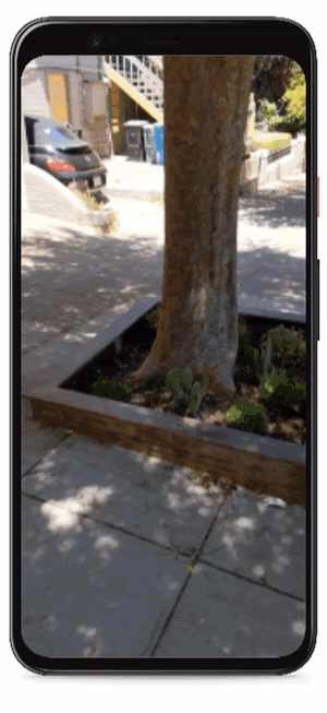
We get a dose of reality pretty immediately: estimation of phone pose in the world comes with basically no guarantees on global consistency.

World Coordinate Space
As ARCore’s understanding of the environment changes, it adjusts its model of the world to keep things consistent. When this happens, the numerical location (coordinates) of the camera and Anchors can change significantly to maintain appropriate relative positions of the physical locations they represent.

These changes mean that every frame should be considered to be in a completely unique world coordinate space. The numerical coordinates of anchors and the camera should never be used outside the rendering frame during which they were retrieved. If a position needs to be considered beyond the scope of a single rendering frame, either an anchor should be created or a position relative to a nearby existing anchor should be used.

Since it is on a per-frame basis, we could get Pose and PointCloud from a Frame. And based on that text, these would then need to be translated through anchors somehow? The first line of Anchor page makes it sound that way:

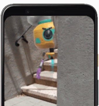
Describes a fixed location and orientation in the real world. To stay at a fixed location in physical space, the numerical description of this position will update as ARCore’s understanding of the space improves.

However, I saw no way to retrieve any kind of identifying context for these points. Ideally I would want “Put an anchor on that distinctive corner of the table” or some such. But still, “Working with anchors” has basic information on how it is useful. But as covered in many points throughout ARCore documentation, use of anchors must be kept at a minimum due to computational expense. Each Anchor is placed relative to a Trackable, and there are many ways to get one. The biggest hammer seems to be getAllTrackables from Sesson, which has a shortcut of createAnchor. There are more narrowly scoped ways to query for Trackable points depending on scenario.

Given what I see of ARCore APIs right now, I’m still a huge fan of future potential. Unfortunately its current state is not a slam dunk for robotics application, and that is not likely to change in the near future due to explicit priorities set by the product team.

But while I had my head buried in studying ARCore documentation, another approach popped up on the radar: the OpenCV AI Kit.

Window Shopping Google ARCore: Design Guidelines

After I got up to speed on fundamental concepts of Google ARCore SDK, I moved on to their design recommendations. There are two parts to their design guidelines: an user experience focused document, and a software development focused variant. They cover many of the same points, but from slightly different perspectives.

Augmented reality is fascinating because it has the potential to create some very immersive interactive experiences. The downside is that an user may get so immersed in the interaction they lose track of their surroundings. Much of the design document described things to avoid in an AR app that boiled down to: please don’t let the user hurt themselves. Many potential problems were illustrated by animated cartoon characters, like this one of an user walking backwards so focused on their phone they trip over an obstacle. Hence one of the recommendations is to avoid making users walk backwards.

Image source: Google

Some of the user experience guidelines help designers avoid weaknesses in ARCore capabilities. Like an admission that vertical surfaces can be challenging, because they usually have fewer identifiable features as compared to floors and tabletops. I found this interesting because some of the advertised capabilities, such as augmented images, are primarily targeted to vertical surfaces yet it isn’t something they’ve really figured out yet.

What I found most interesting was the discouragement of haptic feedback in both the UX design document and the developer document. Phone haptic feedback are usually implemented as a small electric motor spinning an unbalanced weight, causing vibration. This harms both parts of Structure from Motion calculations at the heart of phone AR: vibration adds noise to the IMU (inertial measurement unit) tracking motion, and vibration blurs the video captured by the camera.

From a robotics adaption viewpoint, this is discouraging. A robot chassis will have motors and their inevitable vibrations, some of which would be passed on to a phone bolted to the chassis. The characteristics of this vibration noise would be different from shaky human hands, and given priority of the ARCore team they would work to damp out the human shakiness but robotic motions would not be a priority.

These tidbits of information have been very illuminating, leading to the next step: find more details in the nitty gritty API documentation.

Window Shopping Google ARCore: Tracking

I started learning about Google ARCore SDK by reading the “Fundamental Concepts” document. I’m not in it for augmented reality, but to see if I can adapt machine vision capabilities for robotics. So while there are some interesting things ARCore could tell me about a particular point in time, the real power is when things start moving and ARCore works to track them.

The Trackable object types in the SDK represent data points in three dimension space that ARCore, well, tracks. I’m inferring these are visible features that are unique enough in the visible scene to be picked out across multiple video frames, and whose movement across those frames were sufficient for ARCore to calculate its position. Since those conditions won’t always hold, individual points of interest will come and go as the user moves around in the environment.

From there we can infer such an ephemeral nature would require a fair amount of work to make such data useful for augmented reality apps. We’d need to follow multiple feature points so that we can tolerate individual disappearances without losing our reference. And when new interesting features comes on to the scene, we’d need to decide if they should be added to the set of information followed. Thankfully, the SDK offers the Anchor object to encapsulate this type of work in a form usable by app authors, letting us designate a particular trackable point as important, and telling ARCore it needs to put in extra effort to make sure that point does not disappear. This anchor designation apparently brings in a lot of extra processing, because ARCore can only support a limited number of simultaneous anchors and there are repeated reminders to release anchors if they are no longer necessary.

So anchors are a limited but valuable resource for tracking specific points of interest within an environment, and that led to the even more interesting possibilities opened up by ARCore Cloud Anchor API. This is one of Google’s cloud services, remembering an anchor in general enough terms that another user on another phone can recognize the same point in real world space. In robot navigation terms, it means multiple different robots can share a set of navigation landmarks, which would be a fascinating feature if it can be adapted to serve as such.

In the meantime, I move on to the ARCore Design Guidelines document.

Window Shopping Google ARCore: Concepts

I thought Google’s ARCore SDK offered interesting capabilities for robots. So even though the SDK team is explicitly not considering robotics applications, I wanted to take a look.

The obvious starting point is ARCore’s “Fundamental Concepts” document. Here we can confirm the theory operation is consistent with an application of Structure from Motion algorithms. Out of all the possible type of information that can be extracted via SfM, a subset is exposed to applications using the ARCore SDK.

Under “Environmental Understanding” we see the foundation supporting AR applications: an understanding of the phone’s position in the world, and of surfaces that AR objects can interact with. ARCore picks out horizontal surfaces (tables, floor) upon which an AR object can be placed, or vertical surfaces (walls) upon which AR images can be hung like a picture. All other features build on top of this basic foundation, which also feel useful for robotics: most robots only navigate on horizontal surfaces, and try to avoid vertical walls. Knowing where they are relative to current position in the world would help collision detection.

The depth map is a new feature that caught my attention in the first place, used for object occlusion. There is also light estimation, helping to shade objects to fit in with their surroundings. Both of these allow a more realistic rendering of a virtual object in real space. While the depth map has obvious application for collision detection and avoidance more useful than merely detecting vertical wall surfaces. Light estimation isn’t obviously useful for a robot, but maybe interesting ideas will pop up later.

In order for users to interact with AR objects, the SDK includes the ability to map the user’s touch coordinate in 2D space into the corresponding location in 3D space. I have a vague feeling it might be useful for a robot to know where a particular point in view is in 3D space, but again no immediate application comes to mind.

ARCore also offers “Augmented Images” that can overlay 3D objects on top of 2D markers. One example offered: “for instance, they could point their phone’s camera at a movie poster and have a character pop out and enact a scene.” I don’t see this as a useful capability in a robotics application.

But as interesting as these capabilities are, they are focused on a static snapshot of a single point in time. Things get even more interesting once we are on the move and correlate data across multiple points in space or even more exciting, multiple devices.

Robotic Applications for “Structure From Motion” and ARCore

I was interested to explore if I can adapt capabilities of augmented reality on mobile device to an entirely different problem domain: robot sensing. First I had to do a little study to verify it (or more specifically, the Structure from Motion algorithms underneath) isn’t fundamentally incompatible with robots in some way. Once I gained some confidence I’m not barking up the wrong tree, a quick search online using keywords like “ROS SfM” returned several resources for applying SfM to robotics including several built on OpenCV. A fairly consistent theme is that such calculations are very computationally intensive. I found that curious, because such traits are inconsistent with the fact they run on cell phone CPUs for ARCore and ARKit. A side trip explored whether these calculations were assisted by specialized hardware like “AI Neural Coprocessor” that phone manufacturers like to tout on their spec sheet, but I decided that was unlikely for two reasons. (1) If deep learning algorithms are at play here, I should be able to find something about doing this fast on the Google AIY Vision kit, Google Coral dev board, or NVIDIA Jetson but I came up empty-handed. (2) ARCore can run on some fairly low-frills mid range phones like my Moto X4.

Finding a way to do SFM from a cell phone class processor would be useful, because that means we can potentially put it on a Raspberry Pi, the darling of hobbyist robotics. Even better if I can leverage neural net hardware like those listed above, but that’s not required. So far my searches have been empty but something might turn up later.

Turning focus back to ARCore, a search for previous work applying ARCore to robotics returned a few hits. The first hit is the most discouraging: ARCore for Robotics is explicitly not a goal for Google and the issue closed without resolution.

But that didn’t prevent a few people from trying:

  • An Indoor Navigation Robot Using Augmented Reality by Corotan, et al. is a paper on doing exactly this. Unfortunately, it’s locked behind IEEE paywall. The Semantic Scholar page at least lets me sees the figures and tables, where I can see a few tantalizing details that just make me want to find this paper even more.
  • Indoor Navigation Using AR Technology (PDF) by Kumar et al. is not about robot but human navigation, making it less applicable for my interest. Their project used ARCore to implement an indoor navigation aid, but it required the environment to be known and already scanned into a 3D point cloud. It mentions the Corotan paper above as part of “Literature Survey”, sadly none of the other papers in that section was specific to ARCore.
  • Localization of a Robotic Platform using ARCore (PDF) sounded great but, when I brought it up, I was disappointed to find it was a school project assignment and not results.

I wish I could bring up that first paper, I think it would be informative. But even without that guide, I can start looking over the ARCore SDK itself.

Augmented Reality Built On “Structure From Motion”

When learning about a new piece of technology in a domain I don’t know much about, I like to do a little background research to understand the fundamentals. This is not just for idle curiosity: understanding theoretical constraints could save a lot of grief down the line if that knowledge spares me from trying to do something that looked reasonable at the time but is actually fundamentally impossible. (Don’t laugh, this has happened more than once.)

For the current generation of augmented reality technology that can run on cell phones and tablets, the fundamental area of research is “Structure from Motion“. Motion is right in the name, and that key component explains how a depth map can be calculated from just a 2D camera image. A cell phone does not have a distance sensor like Kinect’s infrared projector/camera combination, but it does have motion sensors. Phones and tablets started out with only a crude low resolution accelerometer for detecting orientation, but that’s no longer the case thanks to rapid advancements in mobile electronics. Recent devices have high resolution, high speed sensors that integrate accelerometer, gyroscope, and compass across X, Y, and Z axis. These 9-DOF sensors (3 types of data * 3 axis = 9 Degrees of Freedom) allow the phone to accurately detect motion. And given motion data, an algorithm can correlate movement against camera video feed to extract parallax motion. That then feeds into code which builds a digital representation of the structure of the phone’s physical surroundings.

Their method of operation would also explain how such technology could not replace a Kinect sensor, which is designed to sit on the fireplace mantle and watch game players jump around in the living room. Because the Kinect sensor bar does not move, there is no motion from which to calculate structure making SfM useless for such tasks. This educational side quest has thus accomplished the “understand what’s fundamentally impossible” item I mentioned earlier.

But mounted on a mobile robot moving around in its environment? That should have no fundamental incompatibilities with SfM, and might be applicable.

Google ARCore Depth Map Caught My Attention

Once I decided to look over an augmented reality SDK with an intent for robotics applications, I went to look at Google’s ARCore instead of Apple’s ARKit for a few reasons. The first is hardware: I have been using Android phones so I have several pieces of ARCore compatible hardware on hand. I also have access to computers that I might be able to draft into Android development duty. In contrast, Apple ARKit development requires MacOS desktop machines and iOS hardware, which is more expensive and rare in my circles.

The second reason was their announcement that ARCore now has a Depth API. Their announcement included two animated GIFs that caught my immediate attention. The first shows that they can generate a depth map, with color corresponding to distance from camera.

ARCore depth map
Image source: Google

This is the kind of data I had previously seen from a Xbox 360 Kinect sensor bar, except the Kinect used an infrared beam projector and infrared camera to construct that depth information on top of its RGB camera. In comparison, Google’s demo implies that they can derive similar information from just a RGB camera. And given such a depth map, it should be theoretically possible to use it in a similar fashion to a Kinect. Except now the sensor would be far smaller, battery powered, and works in bright sunlight unlike the Kinect.

ARCore occlusion
Image source: Google

Here is that data used in ARCore context: letting augmented reality objects be properly occluded by obstacles in the real world. I found this clip comforting because its slight imperfections assured me this is live data of a new technology, and not a Photoshop rendering of what they hope to accomplish.

It’s always the first question we need to ask of anything we see on the internet: is it real? The depth map animation isn’t detailed enough for me to see if it’s too perfect to be true. But the occlusion demo is definitely not too perfect: there are flaws in the object occlusion as the concrete wall moved in and out of the line of sight between us and the animated robot. This is most apparent in the second half of the clip, as the concrete wall retreated we could see bits of stair that should have been covered up by the robot but is still visible because the depth map hadn’t caught on yet.

Incomplete occlusion

So this looks nifty, but what was the math magic that made it possible?

Might A Robot Utilize Google ARCore?

Machine vision is a big field, because there are a lot of useful things we can do when a computer understands what it sees. In narrow machine-friendly niches it has become commonplace, for example the UPC bar code on everyday merchandise is something created for machines to read, and a bar code reader is a very simplified and specific niche of machine vision.

But that is a long, long way from a robot understanding its environment through cameras, with many sub sections along the path which are entire topics in their own right. Again we have successes in narrow machine-friendly domains such as a factory floor set up for automation. Outside of environments tailored for machines, it gets progressively harder. Roomba and similar robot home vacuums like Neato could wander through a human home, but their success depends on a neat and tidy spacious home. As a home becomes more cluttered, success rate of robot vacuums decline.

But they’re still using specialized sensors and not a camera with vision comparable to human sight. Computers have no problems chugging through a 2D array of pixel data, but extracting useful information is hard. The recent breakthrough in deep learning algorithms opened up more frontiers. The typical example is a classifier, and it’s one of the demos that shipped with Google AIY Vision kit. (Though not the default, which was the “Joy Detector.”) With a classifier the computer can say “that’s a cat” which is a useful step toward something a robot needs, which is more like “there’s a house pet in my path and I need to maneuver around it, and I also need to be aware it might get up and move.” (This is a very advanced level of thinking for a robot…)

The skill to pick out relevant physical structure from camera image is useful for robots, but not exclusively to robots. Both Google and Apple are building augmented reality (AR) features into phones and tablets. Underlying that feature is some level of ability to determine structure from image, in order to overlay an AR object over the real world. Maybe that capability can be used for a robot? Time for some research.